GNSS-A time series data

Japanese page is here

The time series data of the seafloor positions measured using the GNSS-A technique is available at this page.
For details of the observation method, please see Yokota et al. (2018, Sci. Data).
The data released in this page is for researchers.

When using the time series data

  • The time series data is licensed under Creative Commons Attribution Non Commercial 4.0 International license.
  • When using the data in a research paper, please cite Yokota et al. (2018, Sci. Data).
  • In our data analysis routine, old data are reanalyzed when new observation data are updated. Please be careful of the data file version.

  • Notes on the data

  • Coseismic and postseismic displacements are not corrected.
  • Data is available in ECEF coordinates and local ENU coordinates. Please select the appropriate coordinate system when using the data.
  • The horizontal precision is estimated to be approximately 2-3 cm (1σ). However, the error may be larger due to turbulence in the underwater sound speed structure.
  • The precision of the vertical component is 2-3 times worse compared to the horizontal components.
  • The results may change due to updates in the data analysis method.
  • Data before Feb. 2020 are aligned to the F3 solutions of the Geospatial Information Authority of Japan (ITRF 2005). Data after Feb. 2020 are aligned to the latest version of the ITRF. Please see the Readme file of each dataset for details.

  • Some of the analysis results use GEONET 1-sec data and F3 solutions (provided by the GSI).
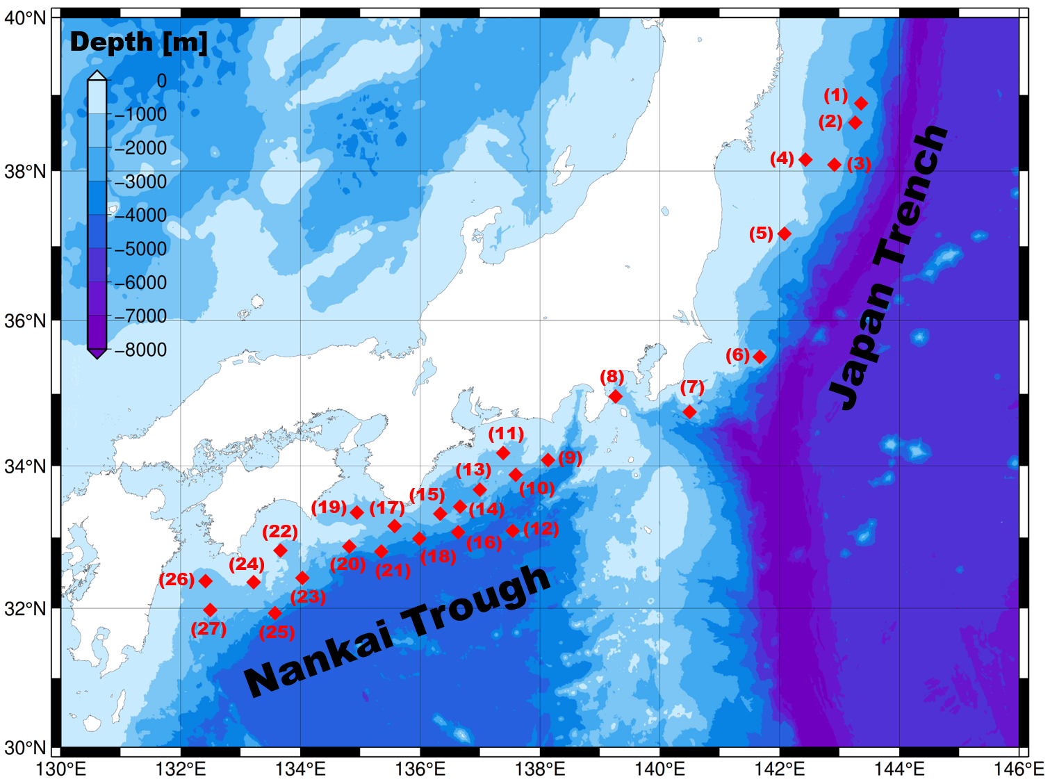
  • Map of the GNSS-A sites

    Data

    Site name Site name Site name
    (1) KAMN (10) TOK2 (19) MRT1
    (2) KAMS (11) TOK3 (20) MRT2
    (3) MYGI (12) ZENW (21) MRT3
    (4) MYGW (13) KUM1 (22) TOS1
    (5) FUKU (14) KUM2 (23) TOS2
    (6) CHOS (15) KUM3 (24) ASZ1
    (7) BOSN (16) KUM4 (25) ASZ2
    (8) SAGA (17) SIOW (26) HYG1
    (9) TOK1 (18) SIO2 (27) HYG2


    Latest data Dec. 04, 2024 *ITRF2020
    (1)-(6) before the Tohoku Earthquake Mar. 31, 2017 *ITRF2005 (F3-solution-based)
    coseismic movements at (1)-(6) Mar. 31, 2017 *ITRF2005 (F3-solution-based)

    Format of the xyz data

    The positions are written in ECEF coordinates (X, Y, Z).

    Line 1    data version (updated date)
    Line 2    site name; reference coordinate system
    Line 3    description of each column
    Line 4-   observation start date; absolute positions [XYZ coordinates (m)]; equipment code (A:-2002/07, B:-2008/04, C:2008/04-); vessel code (K:Kaiyo, M:Meiyo, S:Shoyo, T:Takuyo); observation end date

    Format of the ENU data

    The local cartesian coordinates (defined so that east, north, up are positive) tangent to the origin are written.

    Line 1    data version (updated date)
    Line 2    site name; reference coordinate system
    Line 3    origin of the local cartesian coordinate system (latitude, longitude, ellipsoidal height)
    Line 4    position of reference epoch with (E, N, U = 0.0, 0.0, 0.0) from origin point described in Line 3
    Line 5-   observation start date; absolute positions [ENU coordinates (m)]; equipment code; vessel code; observation end date

    Format of coseismic movements due to the Tohoku Earthquake

    Movements in xyz-data & enu-data are calculated based on the formats above.

    Lines 1-3    headers
    Line 4    sites; observation date before Mar. 11, 2011; vessel code; observation date after Mar. 11, 2011; vessel code; movements [m]